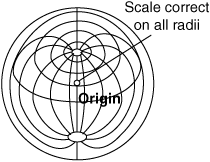
azimuth equidistant projection
- azimuth equidistant projection
A nonperspective map projection drawn in such a way that all distances from the point of tangency are correct to scale. Bearings are correct only when measured from the origin. Areas are not equal. Great circles are straight lines only if they pass through the origin, while rhumb lines are curved.
Aviation dictionary.
2014.
Look at other dictionaries:
azimuthal equidistant projection — azimuth′al equidis′tant projec′tion n. geo a cartographic projection in which the shortest distance between any point and a central point is a straight line, such a line representing a great circle through the central point • Etymology: 1940–45 … From formal English to slang
Scale (map) — The scale of a map is defined as the ratio of a distance on the map to the corresponding distance on the ground. If the region of the map is small enough for the curvature of the Earth to be neglected, then the scale may be taken as a constant… … Wikipedia
Polar coordinate system — Points in the polar coordinate system with pole O and polar axis L. In green, the point with radial coordinate 3 and angular coordinate 60 … Wikipedia
latitude — Synonyms and related words: Antarctic Zone, Arctic Circle, Arctic Zone, Cartesian coordinates, Frigid Zones, Lambert conformal projection, Mercator projection, Miller projection, Torrid Zone, Tropic of Cancer, Tropic of Capricorn, Variable Zones … Moby Thesaurus
longitude — Synonyms and related words: Antarctic Zone, Arctic Circle, Arctic Zone, Cartesian coordinates, Frigid Zones, Lambert conformal projection, Mercator projection, Miller projection, Torrid Zone, Tropic of Cancer, Tropic of Capricorn, Variable Zones … Moby Thesaurus
Su Song — 蘇頌 (Sū Sòng) Born 1020 near Quanzhou Died 1101 (aged 80–81) Nationality Chinese … Wikipedia
navigation — navigational, adj. /nav i gay sheuhn/, n. 1. the act or process of navigating. 2. the art or science of plotting, ascertaining, or directing the course of a ship, aircraft, or guided missile. [1520 30; < L navigation (s. of navigatio) a voyage.… … Universalium
astronomical map — Introduction any cartographic representation of the stars, galaxies, or surfaces of the planets and the Moon. Modern maps of this kind are based on a coordinate system analagous to geographic latitude and longitude. In most cases, modern… … Universalium

